Weather pattern change to bring first big taste of summer to eastern half of US
A live TV news station covering breaking news and traffic for Colorado Springs, Pueblo, and Southern Colorado with a strong investigative team A major pattern change is set to bring the hottest conditions of the year so far to the central and eastern US, bringing daily high temperatures up to 15 degrees above what’s typical for June. This comes as sweltering heat over the West expands east, with an additional push of hot air from Mexico and the jet stream slowly shifting north over the states. High temperatures will rise from the Plains and Upper Midwest to the Southeast, Ohio Valley and mid-Atlantic, threatening dozens of daily high temperature records. The heat index could reach triple digits in St. Louis, which has yet to reach the low 90s in 90s this year, is expected to reach 96 degrees on Thursday. Washington, DC will be the hottest day so far in the year, with temperatures reaching mid-90s, around 10 degrees higher than normal. The predicted hot summer is predicted to continue throughout the week.

Publicado : hace 12 meses por en Weather
(CNN) — A surge of July-like heat will usher in the hottest conditions of the year so far to the central and eastern US as a major pattern change unfolds.
Daily high temperatures will surge up to 15 degrees above what’s typical for June through at least Saturday and threaten dozens of daily high temperature records as sweltering heat in place over the West expands east.
And the heat isn’t dropping by for a quick visit, even if it ebbs in some places. There are signs it’ll stick around for the long haul as a predicted hot summer kicks into gear.
Parts of the West have been baking since a stifling heat dome set up over the region last week. Now, some of that heat and an additional push of hot air from Mexico will envelop more of the US as the jet stream – a river of fast-moving air in the upper atmosphere that separates warm air from cold air – slowly shifts north over the central and eastern states.
The late-week warmup will be very brief for a few locations. High temperatures will surge into the 90s Wednesday in parts of the northern Plains and Upper Midwest before a cold front wipes out the heat Thursday.
The heat will have staying power elsewhere. Heat will ramp up Thursday from the Plains to the East Coast, marking a considerable change from seasonably cool conditions earlier in the week.
Highs in the upper 80s and 90s will be common from the Plains and Midwest to the Southeast, Ohio Valley and mid-Atlantic. Several cities will experience the warmest day of the year so far Thursday, but temperatures will be short of record levels.
Humidity will build alongside the heat and make conditions feel even more uncomfortable.
The thermometer has yet to climb out of the low 90s in St. Louis this year, but that will change Thursday with a high around 96 degrees. The heat index – how air feels to the human body – could approach triple digits.
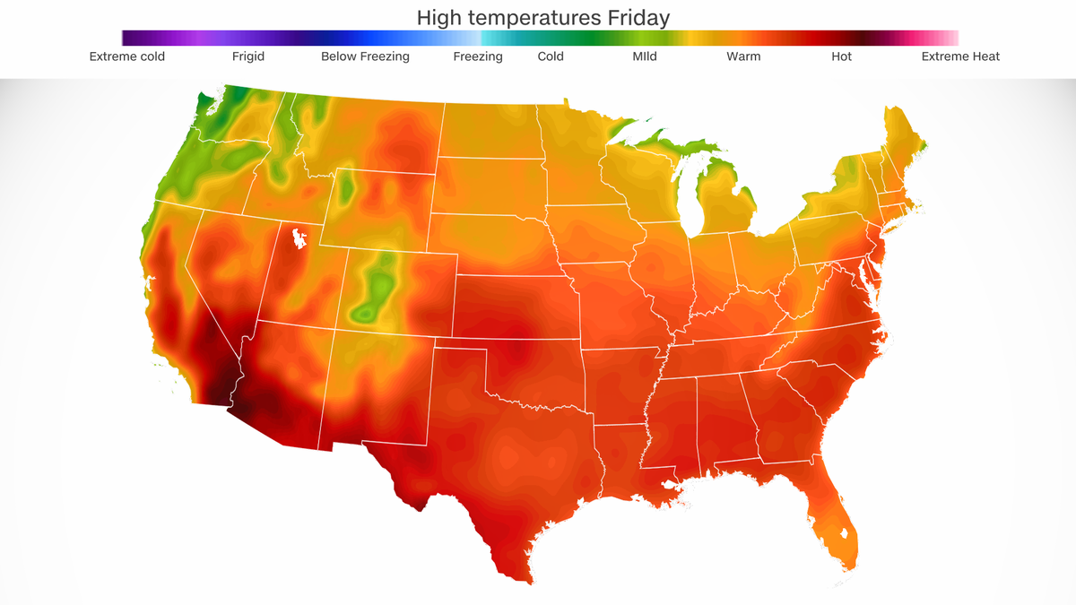
Temperatures will warm even more Friday for much of the Gulf Coast, Southeast and mid-Atlantic as hot air surges north. Highs well into the 90s will stretch from Texas through Georgia and the Carolinas north into parts of Pennsylvania and New Jersey.
Friday will be the hottest day of the year so far in Washington, DC. The high temperature could approach the mid-90s, which is about 10 degrees higher than normal.
Heat will be at its worst by Saturday for much of the Gulf Coast and Southeast but ease slightly for areas farther north with the passage of a cold front.
Atlanta is expected to top out near 99 degrees on Saturday, which would be a temperature record for the date and the hottest reading of the year so far. If the city were to hit 100 degrees it would be the first triple-digit temperature there since August 2019.
Highs in the upper 90s and low 100s could also break Saturday’s high temperature records in multiple other Southeast cities including: Birmingham and Montgomery, Alabama, and New Orleans and Baton Rouge, Louisiana.
Expansive heat will build once again for much of the central and eastern US on Sunday as the jet stream settles near the US-Canada border and high pressure builds in the upper atmosphere.
Anyone hoping for relief is out of luck. A long-lasting heat dome will build early next week in the East and send temperatures soaring even higher.
